 iPhone iScene
lukeおじさんのページ
iPhone iScene
lukeおじさんのページ
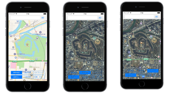
標準地図、航空写真、ハイブリット、位置情報表示
ViewController.m
#import <MapKit/MapKit.h>
#import "ViewController.h"
@interface ViewController () <MKMapViewDelegate>
@property (weak, nonatomic) IBOutlet MKMapView *mkMap;
@end
@implementation ViewController
- (void)viewDidLoad
{
[super viewDidLoad];
// Do any additional setup after loading the view, typically from a nib.
}
- (void)didReceiveMemoryWarning
{
[super didReceiveMemoryWarning];
// Dispose of any resources that can be recreated.
}
#pragma mak
// 地名検索(ジオコーティング)
- (IBAction)searchPlace:(UITextField *)sender {
CLGeocoder *gc = [CLGeocoder new];
// ジオコーティング実行
CLGeocodeCompletionHandler hnd = ^(NSArray *placemarks, NSError *error){
// 位置の設定
CLPlacemark *pm = (CLPlacemark *) placemarks[0];
CLLocationCoordinate2D lc = pm.location.coordinate;
// 領域の確定
MKCoordinateSpan cs = MKCoordinateSpanMake(0.01, 0.01);
// 地図の表示
MKCoordinateRegion cr = MKCoordinateRegionMake(lc, cs);
[self.mkMap setRegion:cr animated:YES];
};
[gc geocodeAddressString:sender.text completionHandler:hnd];
}
#pragma mark - MKMapViewDelegate Method
// 地図表示の変更後
-(void)mapView:(MKMapView *)mapView regionDidChangeAnimated:(BOOL)animated {
// 中央位置の取得
CLLocationCoordinate2D crd = mapView.centerCoordinate;
// 領域の取得
MKCoordinateSpan spn = mapView.region.span;
// 表示
NSLog(@"位置{%.2f, %.2f}, 領域{%.2f, %.2f}",
crd.latitude, crd.longitude,
spn.latitudeDelta, spn.longitudeDelta);
}
// アノテーション表示の管理
-(MKAnnotationView *)mapView:(MKMapView *)mapView
viewForAnnotation:(id<MKAnnotation>)annotation {
// 再利用可能オブジェクト取得
MKPinAnnotationView *pa = (MKPinAnnotationView *)
[mapView dequeueReusableAnnotationViewWithIdentifier:@"pin"];
if (pa == nil) {
// オブジェクト作成
pa = [[MKPinAnnotationView alloc] initWithAnnotation:annotation reuseIdentifier:@"pin"];
// 設定(ドロップ時のアニメーション)
pa.animatesDrop = NO;
// 設定(ピンの色)
pa.pinColor = MKPinAnnotationColorPurple;
// 設定(ピンタップ時の情報表示)
pa.canShowCallout = YES;
// 設定(ピン画像)
pa.image = [UIImage imageNamed:@"pin.png"];
}
return pa;
}
#pragma mark - ActionMetod Method
- (IBAction)change3D:(id)sender {
// 地図の中心地点
CLLocationCoordinate2D centerCoordinate =
CLLocationCoordinate2DMake(34.687277, 135.525856);
// カメラのセット地点
CLLocationCoordinate2D fromEyeCoordinate =
CLLocationCoordinate2DMake(34.689659, 135.518367);
// 500m上空からの視点
CLLocationDistance eyeAltitude = 500.0;
// カメラをセット
MKMapCamera *camera =
[MKMapCamera cameraLookingAtCenterCoordinate:centerCoordinate
fromEyeCoordinate:fromEyeCoordinate
eyeAltitude:eyeAltitude];
[self.mkMap setCamera:camera animated:YES];
}
// マップタイプ選択
- (IBAction)selectStyle:(UISegmentedControl *)sender {
//self.mkMap.mapType = sender.selectedSegmentIndex;
// ボタン判定
switch (sender.selectedSegmentIndex ) {
case 0: // 標準地図
self.mkMap.mapType = MKMapTypeStandard;
break;
case 1: // 航空写真
self.mkMap.mapType = MKMapTypeSatellite;
break;
case 2: // ハイブリット
self.mkMap.mapType = MKMapTypeHybrid;
break;
default:
break;
}
}
// トラッキングモード選択
- (IBAction)selectTracking:(UISegmentedControl *)sender {
// ボタン判定
switch (sender.selectedSegmentIndex) {
case 0: // 追跡なし
[self.mkMap setUserTrackingMode:MKUserTrackingModeNone
animated:YES];
// 現在地印の消去
self.mkMap.showsUserLocation = NO;
break;
case 1: // 位置追跡
[self.mkMap setUserTrackingMode:MKUserTrackingModeFollow
animated:YES];
break;
case 2: // 位置、方位追跡
[self.mkMap setUserTrackingMode:MKUserTrackingModeFollowWithHeading
animated:YES];
break;
default:
break;
}
}
// 地図のロングプレス時
- (IBAction)dorpPin:(UILongPressGestureRecognizer *)sender {
// if (sender.state == UIGestureRecognizerStateRecognized) {
//
// //NSLog(@"%s", __func__);
//
// // MapView取得
// MKMapView *mv = (MKMapView *)sender.view;
//
// // 位置情報を取得
// CGPoint pnt = [sender locationInView:mv];
// CLLocationCoordinate2D crd = [mv convertPoint:pnt
// toCoordinateFromView:mv];
//
// // アノテーション追加
// {
// MKPointAnnotation *ant = [MKPointAnnotation new];
//
// // 設定(位置)
// ant.coordinate = crd;
// // 設定(表示テキスト)
// ant.title = @"タイトル";
// ant.subtitle = @"サブタイトル";
//
// [mv addAnnotation:ant];
//
// }
//
// }
// ジェスチャーの確定判定
if (sender.state == UIGestureRecognizerStateRecognized) {
// MapView取得
MKMapView *mv = (MKMapView *) sender.view;
// 位置情報を取得
CGPoint pnt = [sender locationInView:mv];
CLLocationCoordinate2D crd = [mv convertPoint:pnt
toCoordinateFromView:mv];
// 標高値の取得
/*
国土地理院「電子国土ポータル」のAPIを使用
http://portal.cyberjapan.jp/help/development.html#api
*/
// HTTPリクエスト設定
NSString *url = [NSString stringWithFormat:
@"http://cyberjapandata2.gsi.go.jp/"
@"general/dem/scripts/getelevation.php"
@"?lon=%f&lat=%f&outtype=JSON",
crd.longitude, crd.latitude];
NSLog(@"%@", url);
NSURLRequest *req =
[NSURLRequest requestWithURL:[NSURL URLWithString:url]
cachePolicy:NSURLRequestReloadIgnoringLocalCacheData
timeoutInterval:3.0];
// サーバ同期接続
NSData *res =
[NSURLConnection sendSynchronousRequest:req
returningResponse:nil
error:nil];
// JSONデータ取得
NSDictionary *dir =
[NSJSONSerialization JSONObjectWithData:res
options:NSJSONReadingAllowFragments
error:nil];
// アノテーション追加
{
MKPointAnnotation *ant = [MKPointAnnotation new];
// 設定(位置:緯度・経度を指定)
ant.coordinate = crd;
// 設定(表示テキスト)
ant.title = [NSString stringWithFormat:
@"標高:%@m", dir[@"elevation"]];
ant.subtitle = [NSString stringWithFormat:
@"データソース:%@", dir[@"hsrc"]];
[mv addAnnotation:ant];
}
}
}
@end
GitHub Map
▫️参考ページ
コメントをお書きください